The order, issued to the wealthy coastal region of Montecito, comes five years after landslides killed 23 residents.
Officials in Santa Barbara County, California, issued an immediate evacuation order for the flooded city of Montecito, as heavy rain and high winds continue to hit the west coast of the United States.
Nearly 10,000 people will be displaced in and around the affluent coastal region, which lies between the Pacific Ocean and the surrounding hilly areas. The town is home to celebrities like TV presenters Oprah Winfrey and the royal couple Prince Harry and Meghan Markle.
Santa Barbara County Sheriff Bill Brown explained Monday that the decision to evacuate was “based on a continued high rate of rain.” He added that “there is no indication that that will change before nightfall”.
California is under one federal state of emergency as a series of “atmospheric rivers” hit the state, bringing intense rains to an area vulnerable after years of drought.
Officials from the governor’s office on Monday increased the storm’s death toll from 12 to 14, as residents suffered from flooding, downed power lines and downed trees. The Montecito Fire Department reported their website was down “due to high traffic”.
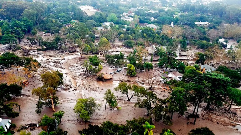
The order to evacuate from Montecito was given almost 5 years after heavy rainfall caused Deadly mudslides in the city in 2018. The rushing mud pushed huge rocks and rivers of debris down the city’s hillside, crushing homes and killing at least 23 people, according to the California Office of Emergency Services.
Monday’s evacuation order was also issued a day before the anniversary of the 2005 landslide that devastated the small community of La Conchita about 40 kilometers south of Santa Barbara, damaging dozens of homes and killing 10 people.
The area has been hit by wildfires, which, combined with heavy rainfall, has officials concerned about the possibility of another deadly landslide during this week’s storm.
Barker Pass is closed from SR 192 to the Salinas Road roundabout due to flooding. Please do not drive today if possible. pic.twitter.com/INsHE7xz8Q
– CHP Santa Barbara (@CHP_SantaBarb) January 9, 2023
Climate change has increased the intensity and frequency of burns in the western United States, and Montecito has also seen a series of fires in recent years. The Thomas Fire in 2017 burned 281,000 acres nearby, while the smaller Alisal Fire burned another 16,970 acres in 2018.
The US National Weather Service said Monday that those wildfires have left the region “burn scars” where the landscape has yet to recover. “Less vegetation increases the risk” of natural disasters like landslides, the agency explains on its website.
“Additional heavy rains on Tuesday will exacerbate ongoing flooding and continue to pose the risk of flash flooding and landslides, particularly over areas with recent burn scars,” it said. .
The storms of the past few weeks have pushed rainfall 400 to 600 percent higher than the average total, the agency explained. It predicts “no significant relief” to “the wet weather pattern that is plaguing much of California.”
“While areas from Central to Northern California will see a pause in recent heavy rain late today through early Tuesday, it will be short-lived as the next wave in the parade is unlikely to ever come. The end hours of intensely wet Pacific systems will push heavier rainfall across all of California on Tuesday, the agency said.